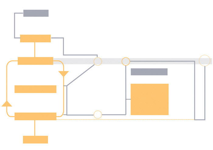
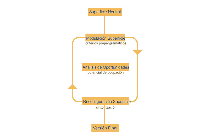
Versioning machine diagram
A Format, unlike a form, does not refer to a closed or specific figure as starting point. In a spatial sense, it stresses the organization of a set of possible situations. Such organizations –like in a highway network or in an airport- are entirely determined by logics or protocols whose spatial and formal outcomes are far more relevant than those produced by a complete and anticipated form. The agents involved and the protocols (timing, interactions) followed by those agents generate those sets of situations.
Formatting space is a means of framing a possible place, or an event that might take place.
Within these parameters, the project turns into an exploration of possible situations, a process that implies the actualization of virtual spatial organizations.
Once such place is imagined, and submitted to the constrains that surround it and make it possible (its economical, technological and sociological environment), the set of condensations, movements, occupation frequencies, spatial and time patterns involved, are formatted by specific spatial parameters. It must fit into the rules of the general system; its logic must be adapted to them. This way, the project shifts its attention towards spatial organization, towards management of time and the set of intensities that modulate space.
In this respect, a spatial format admits variation of location, size and duration. Its spatial properties will be intact while its fundamental logic remains. Any material organization of information, any audio-visual or computer format possesses such flexibility. An unlimited number of versions of a format can be done, without it losing its characteristics. This opens the possibility to induce transformations when formatting space, to use formats in a way that effective changes on the environment (in an open sense) are achieved.
New agents of change can be introduced by means of the spatial format. Its success does not depend upon the invariability of the elements of what it is made.
Project and product are no longer opposing extremes of a process –beginning and end-. They are collaboratively elaborated and condensed in the spatial format.
On the other hand, format determines content. It structures and systematises the materials being formatted. All contents adapted to a format are potentially connectable. This is what gives to formats its capacity of proliferation. Diverse materials, once formatted, amplify its potential of connection to other materials. This acquisition of connectivity is a means of overlapping and adding some materials that could be easily considered as incompatible.
Some characteristics of new spatial formats have been described so far. Other properties can be achieved by using existing formats: the appropriation of a well known format adds some new elements to the material that is formatted. Any existing format contains a set of default elements that comprises a certain corporate or economic identity, a segment of consumers, and so on. And this is what is seamlessly incorporated to the project materials. Any given format, slightly modified, including imperceptible infiltrations of alien materials, acquires a capacity for proliferation that those materials alone do not have.
Project and product are no longer opposing extremes of a process –beginning and end-. They are collaboratively elaborated and condensed in the spatial format.
Versioning machine
Interest maps
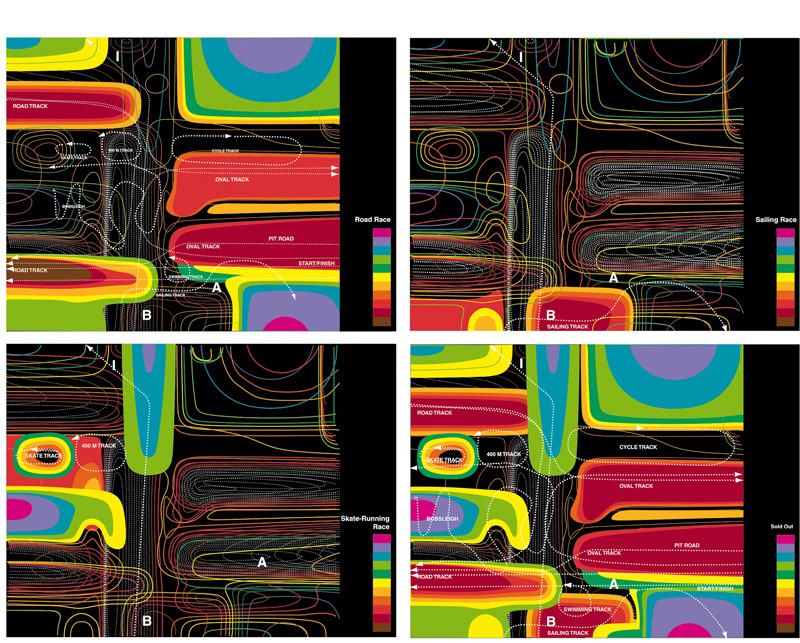
The Calverton Racetrack Project
Car races and all big sport events in general, usually concentrate over a few days a year. Nevertheless, these events move a great number of people occupying great areas around the venues. During those days the intensity and concentration of use is such that it pays off the facilities inactivity for the rest of the year. Following an already detectable trend in some of the big racetracks, this project explores the possibility of a sport facility where that intensity of use is kept in a permanent way, It will be necessary to imagine an architectural structure to achieve that, a spatial organization able to host and manage a continuous activity program.
Probably, the resulting place is a space where you can contemplate any competition simultaneously, a combination of all cycles and speeds: from formula 1 to tortoise race, from planes to snails. A landscape to walk or drive, to wander following different events.
Saturation of uses becomes a first requirement for the project. All kind of tracks and all kind of uses for those tracks are concentrated, saturating the place with different guidelines for occupation. In this context, the project has to provide big neutral surfaces that allow this congestion without neither solid program nor fixed spatial divisions. Therefore grandstands have to be amplified to become an open landscape, an inhabitable infrastructure.
This project seeks to capture a space where protocols of use, rhythms of occupation, cycles, frequencies, revolutions, speeds, possible accidents, and the unexpected are superimposed. The interaction of all these agents simultaneously activates certain areas, overlapping and balancing the different sectors of interest.
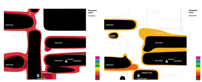
Floorplan value maps
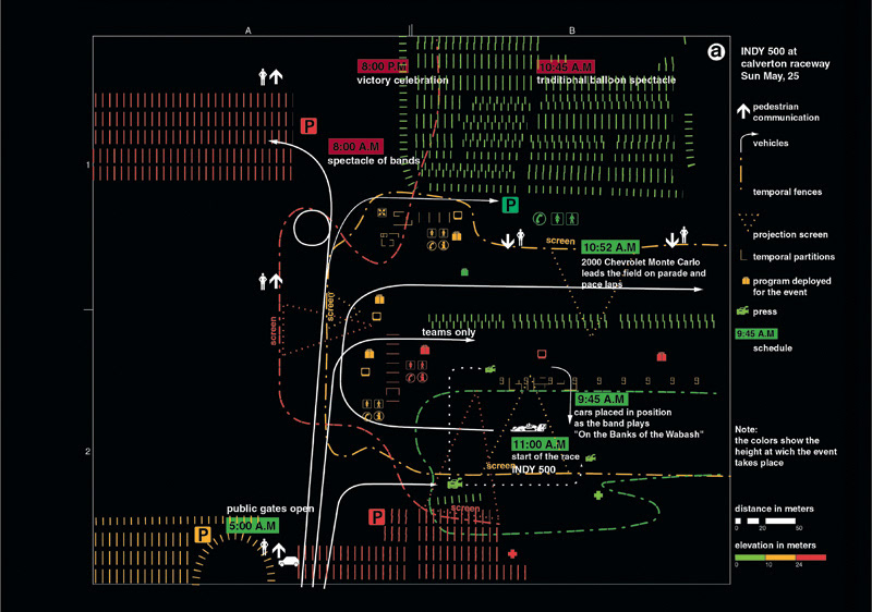
Indy 500 Sunday May 25th Scenario
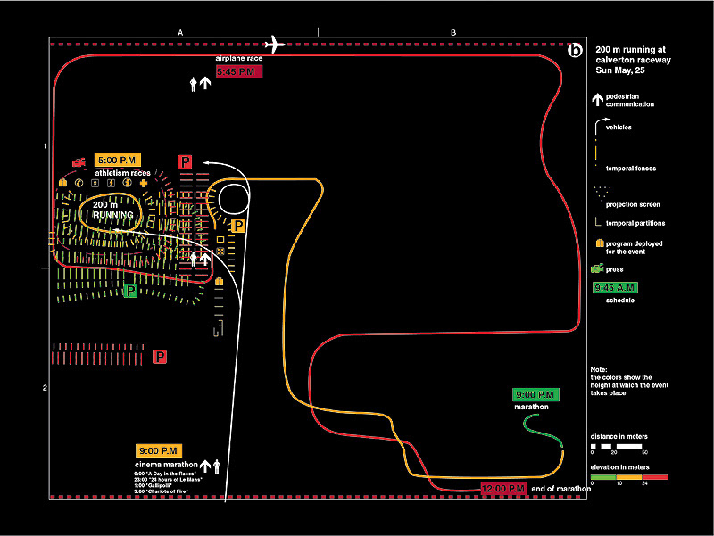
200 m running. Sunday May 25th Scenario
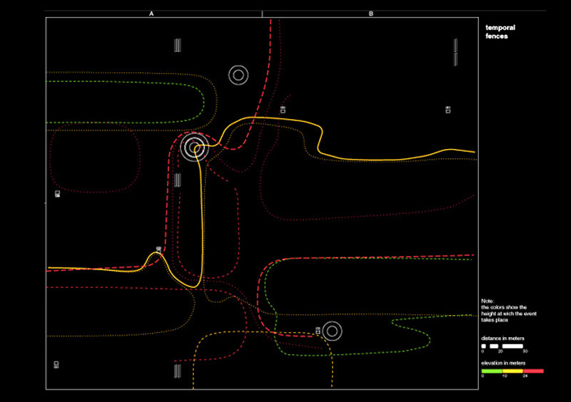
Temporal fences map
The documents included here belong to the main grandstand of the sport complex, Grandstand v.4.2. The three principal levels of the grandstand are interconnected, and segments of the main tracks (formula INDY, NASCAR, motorcycle, marathon, sailing, airplanes, fast animals: pigeons, horses, greyhounds), as well as some smaller complete tracks (velodrome, karts, athleticism, swimming, slow animals: snails) run through the three of them. If grandstands are usually located in the areas of best visibility, speed and risk, Grandstand v.4.2. is right where maximum activity takes place.
Once the final version is selected, the determining factor in the project’s organization is the location of seats in the stands. Each combination of races and competitions generates different patterns of prices (like a theater with changing prices for the orchestra and the boxes). The superimposition of the price areas for the whole of the predictable situations indicates the general floor value.
Calverton Racetrack Project is devised as the propagation of a series of details (possible moves inside a proposed general system) to be run according to the interaction of the different agents at play.
According to the location of these areas, the auxiliary uses and facilities of all kind are distributed.
For each one of the scenarios of use, the spatial organization responds to the definition of different price sectors, the circulation an access to those sectors, the uses activated along those circulations and the occupation of the area. Besides it has to take into account the advertising and information opportunities along with the public movement and the provision of parking areas in each case.
Therefore, every organization will be adapted to a network of spatial and temporal protocols, to a specific sort of weather pattern, providing the suitable activation for each area. The Calverton Racetrack Project is devised as the propagation of a series of details (possible moves inside a proposed general system) to be run according to the interaction of the different agents at play. These constructive details refer to factors like the relation between area and speed or the location of the seat and the gradient of prices that this location generates.
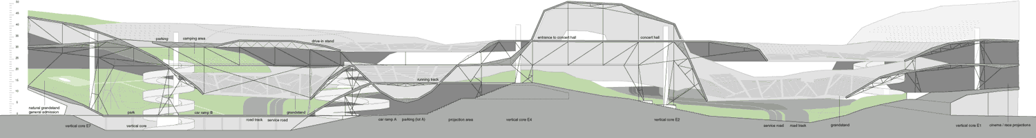
Long section through racing tracks
Juan Elvira and Clara Murado, 2001. First published in Fisuras Magazine